I was inspired to buy a Michigan road atlas after a trip to the Mouth of Two Hearted River State Forest Campground in the eastern Upper Peninsula in which I got lost. I had set up my navigation on my phone when I was still close enough to civilization to have service, and thought that I would be fine. However, in the middle of nowhere, I lost service and then was left with only a fold-up Michigan map published during the Engler administration (that’s the 1990’s, for you young ones). While the map was not terribly detailed, it did let me know that when I reached the town of Wolf Lake, I had gone way too far, so at least I knew to turn around. On my way back, I discovered that there was a sign for the campground visible from my new direction, but the sign that I should have seen on my way through the first time had been knocked down, hence my getting lost. I was struck by the fact that I was pretty helpless once my phone service had gone bye-bye, and resolved to figure out a better plan for next time.

Carrying a Michigan road atlas has come in handy numerous times. Last spring I was hoping to get in a few North Country Trail miles near Petoskey, and was caravanning toward the trailhead with my parents, who were driving my mom’s Chevy Malibu. My navigation took me to a sandy seasonal road that I was pretty sure would be a disaster for her car, so I pulled out the atlas and found a more reasonable route. One of the big problems I find with GPS/phone navigation is that people often have them set for the shortest route, which makes sense in the city, but out in the sticks, when the shortest route may involve seasonal roads, it’s not really the quickest route–just the fewest miles. The quickest route may involve more miles but better quality roads.
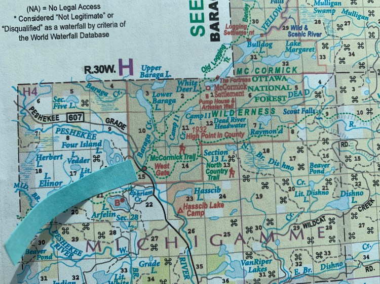
That lesson hit home on a recent trip to the Upper Peninsula. One of my friends and I were camped in the Elliott Donnelly Wilderness off of County Road 550, between Marquette and Big Bay. We were planning to backpack the North Country Trail over the next few days, and wanted to leave a car at the trailhead on Harrison Road near Little Garlic Falls, drive another car to a trailhead near the Silver Lake Basin, and hike the 20 miles in between, before leap-frogging a car to the McCormick Wilderness and continuing our hike. My road atlas showed that we could either take seasonal roads, or head up 550, which is paved, to Big Bay, then cut across to 510, and head back south on 510 to our Silver Lake Basin destination. The atlas showed the paved road trip to be about 90% more miles than the seasonal road option, so we took the seasonal roads. This turned out to be a mistake.

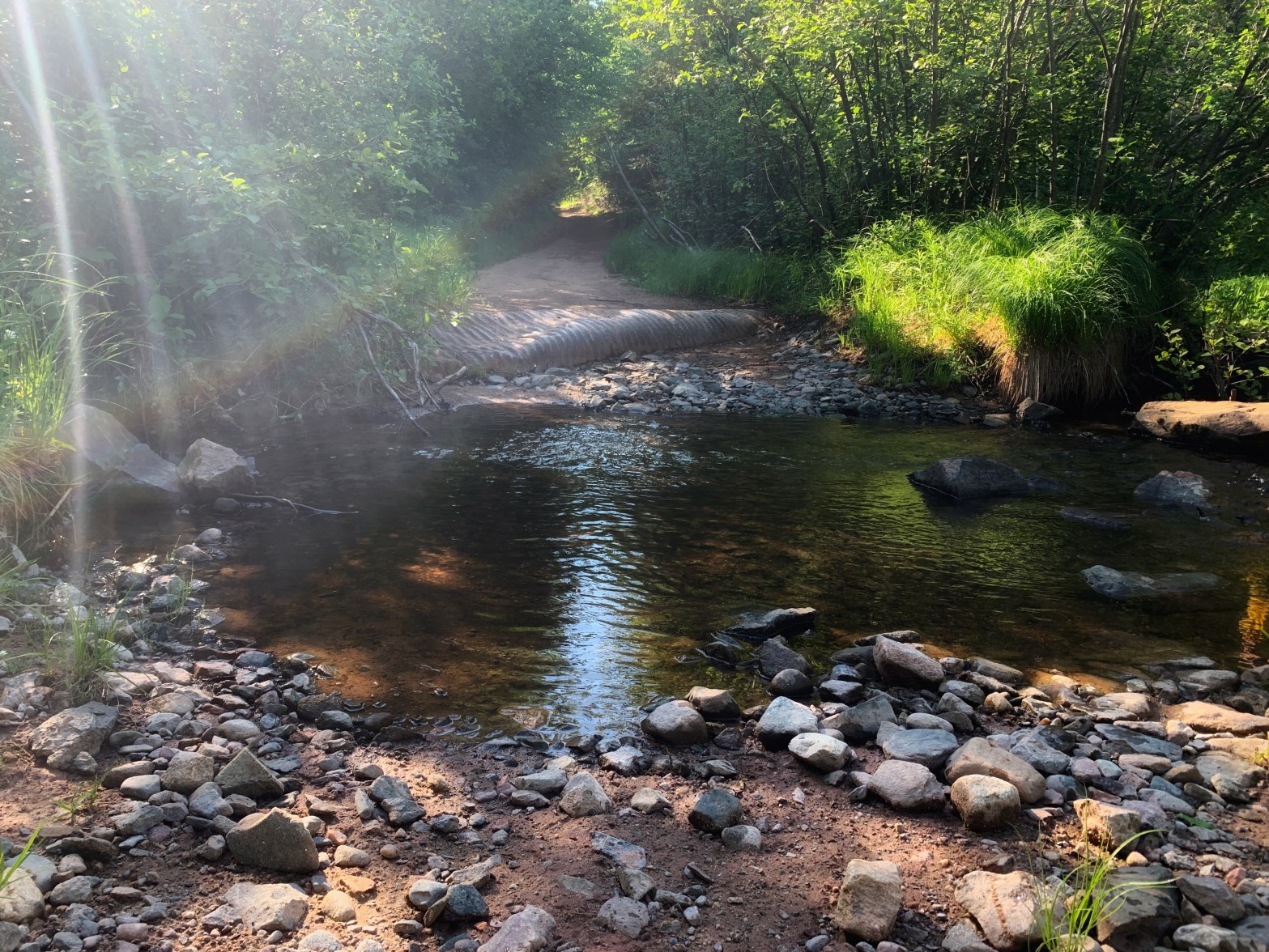
For one thing, some seasonal roads in the U.P. are not really roads, so much as a suggestion of a path. After encountering two stream crossings that deserved bridges, but did not have them, and discovering that a road noted in the atlas that was vital to our plan was actually just a path on someone’s private property, we ended up using the atlas to find an alternate route that did not involve re-crossing the streams, which had been a bit of a gamble in the first place. We came out onto County Road 550 just a few miles north of where we would have started if we had chosen 550 to begin with. We had wasted at least 40 minutes, risked damaging my friend’s vehicle, and had a pretty stressful beginning to the day. In this case, the route that was “shortest” certainly was not the easiest, or the quickest.
A couple of years ago I traded in my Chevy Cruze for a vehicle with all-wheel drive and more ground clearance so that I would be better able to get out to trailheads in remote areas, but that doesn’t mean that I can get down every road on the map. Checking the atlas is a good start, but I need to remember that just because the atlas has something labeled as a road doesn’t mean that it’s going to be passable. My new mantra for the road key is: solid gray/black = good, dotted gray = bad (or at least “proceed with caution”).
Just because the GPS says that a route is “shortest” doesn’t mean it’s the best. A combination of navigation systems coupled with your own common sense is probably the most winning strategy. If you’re traveling within a national forest, a pre-trip call to the local ranger station to ask about road conditions is also a good idea, particularly in winter time, when many roads become snowmobile trails and are not plowed.
While it doesn’t have all the answers, I find that my Michigan road atlas is a huge help for those instances where there is no cell service, or the GPS seems bent on taking me down roads that I would rather not drive. While it might not be the most exciting piece of hiking gear you invest in, it might make your life a lot easier! (The chart cover from West Marine is good protection for it!)
